
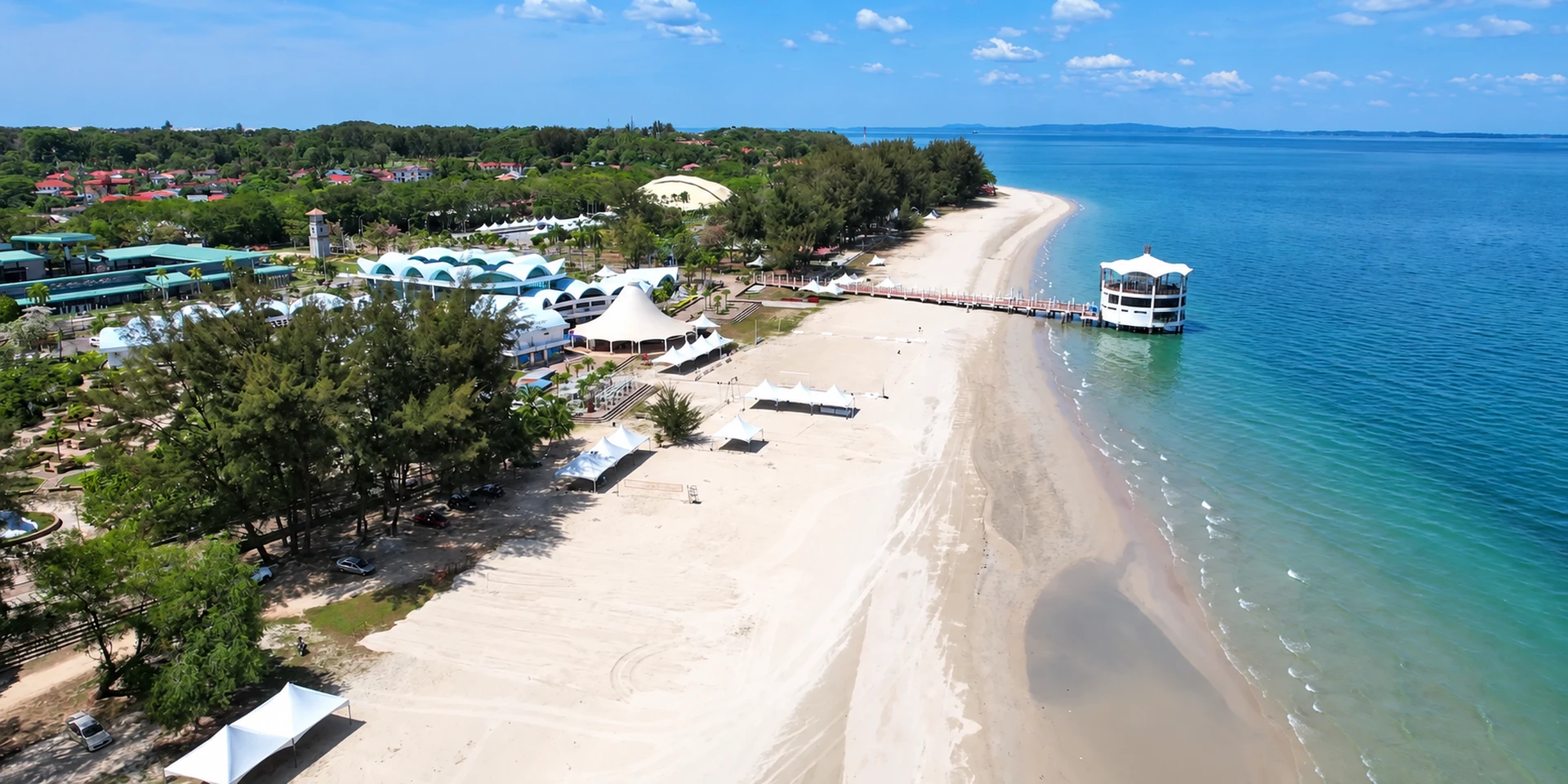
Beaches and sunsets
Labuan’s west coast carries a 9 km stretch of beach that received a Clean Beach Award from the United Nations Environment Programme in 2008, running from Batu Manikar in the north to Sungai Miri. The coast faces west, so sunset is the hour that matters, and the beaches are quiet on weekdays and busy with local families at weekends.
At a glance
| Award | UNEP Clean Beach Award, 2008 |
|---|---|
| Extent | Batu Manikar to Sungai Miri, 9 km |
| Aspect | West-facing, so sunset is the hour |
| Best for | Sunsets, barbecues, swimming |
| Beaches covered | 12 |
The award-winning stretch
Beaches surround the island, with open views of the South China Sea. The 9 km stretch between Batu Manikar Beach and Sungai Miri Beach received the Clean Beach Award from the United Nations Environment Programme in 2008. That is where the local name UN’08 Beach comes from, and it is still the name you will hear.
This is a single continuous shore rather than a set of separate bays, which is why our beach pages often describe one stretch of it under different local names. Where you stop along it is mostly about which facilities you want and how much company.
Source: The 2008 UNEP Clean Beach Award and the Batu Manikar to Sungai Miri extent are from Tourism Malaysia, Labuan Map & Guide (updated December 2023).
Which beach to choose
This page covers twelve beaches. The table is the short way to decide. Facilities on Labuan’s beaches are modest everywhere, so read “facilities” as parking, a stall and somewhere to rinse off rather than a promenade.
| Beach | Coast | Best for |
|---|---|---|
| Batu Manikar | North west | The northern end of the award-winning stretch. Space and quiet |
| Pancur Hitam | West | The most used beach. Families at weekends |
| Layang-Layangan | North west | Sunsets, next to Surrender Point and Peace Park |
| Tanjung Aru | West | Sunsets, and one of the two most recommended viewpoints |
| Sungai Miri | West | The southern end of the award-winning stretch |
| Sungai Labu | West | Quiet, near the homestay area |
| Sungai Pagar | West | Quiet walking |
| Pohon Batu | North | Beachcombing and rock pools at low tide, near the Chimney |
| Tanjung Batu | East | Activity rather than solitude. Close to the geopark site and the war cemetery |
| Tanjung Kubong | North | The coastal landscape, and the coal heritage behind it |
| Lubok Temiang | South | The old mine working nearby, listed on the geopark register |
| UN’08 Clean Beach | West | The award-winning stretch under its local name |
Sunset viewpoints
The long beaches face west, so sunset is the busiest time of day on this coast. Layang-Layangan, next to Surrender Point, and Tanjung Aru are the two most frequently recommended viewpoints. Arrive about forty minutes before the sun goes down: the colour on this coast builds before the sun reaches the water, and the stalls pack up soon after. See sunset spots for the rest.
Beaches and the geopark
Several beaches are also geological sites. Labuan was recognised as a National Geopark on 16 December 2021, and the official register includes the coastal landscape at Tanjung Kubong, the Belait Formation sandstone and the tafoni weathering at Tanjung Batu, and the sea arch, cross bedding and erosion landscape at Tanjung Layang-Layangan. The honeycomb hollows in the rock faces at Tanjung Batu are tafoni, and they are easiest to see at low tide. See the geopark site register.
Source: Recognition date from The Borneo Post, 21 December 2021. Site names from the Labuan Geopark official site of Perbadanan Labuan, read 22 October 2026. Tanjung Batu features from Malay Mail, 5 February 2020.
A note on Palm Beach
Other guides to Labuan list a Palm Beach on the north coast. The name belongs to Palm Beach Resort and Spa, and independent listings for that name in Labuan refer to the property rather than to a separately named public beach. We have not been able to confirm Palm Beach as an officially named beach, so it does not have a page of its own here. The shore in front of the resort is part of the north coast. If you are looking for it by name, that is where it is.
Swimming and safety
- The water is warm all year and the west coast is generally calm, but the open sea is still the open sea. Swim where other people are swimming.
- Jellyfish can appear at the change of the monsoon. Ask locally before swimming if you see any on the sand.
- Currents are usually gentle on this coast but can pick up during monsoon swells on the west-facing beaches.
- There are no lifeguards on Labuan’s beaches. Keep children within reach.
- The sun is stronger than it feels because the sea breeze is cool. Reef-safe sunscreen, a hat and water. See safety and health.
- Take your rubbish with you. The award on this coast was for cleanliness, and keeping it is the local expectation.
Practical notes
- Getting there. The beaches are not walkable from the town centre. A hired car or ride-hailing is the normal way. See getting around.
- When to go. Weekday mornings for quiet, late afternoon for sunset, weekends for the local family atmosphere and whatever stalls are open.
- Facilities. Modest, and not the same at every stop. Pancur Hitam is the best equipped of the west coast beaches. Bring water wherever you go.
- Barbecues. A normal weekend activity on this coast. Clear up fully afterwards.
- Island beaches are a separate trip by boat. See island hopping.
Batu Manikar Beach
Batu Manikar marks the northern end of the 9 km stretch of coast that received a Clean Beach Award from the United Nations Environment Programme in 2008.
What it is
Batu Manikar Beach is one end of the run of coast known locally as UN’08 Beach. The 9 km stretch between Batu Manikar and Sungai Miri Beach was accorded the Clean Beach Award by the United Nations Environment Programme in 2008.
What to expect
This is the northern, quieter end of Labuan’s longest continuous beach. It faces the South China Sea, and the postcard views the island is known for are along this coast.
The long beaches face west across the South China Sea, which is why sunset is the busiest hour of the day on this coast. See sunset and sunrise viewpoints.
Getting there
The beaches are spread around the island and are not walkable from the town centre. You will need a car, a taxi or a ride-hailing service. See getting around Labuan.
Before you go
- There are no lifeguards on Labuan’s beaches. Swim within your depth and watch for currents, particularly near river mouths and headlands.
- Bring water and shade. Facilities vary from beach to beach and could not be verified for this page.
- The island won a UNEP Clean Beach Award for its west coast in 2008. Take everything you brought back off the beach with you.
- Wind and swell change quickly on this coast. If the sea looks wrong, it probably is.
Source: Beach names, the 9 km award-winning stretch and the 2008 UNEP Clean Beach Award from Tourism Malaysia, Labuan Map & Guide (updated December 2023).
| Part of | The 9 km UN’08 stretch |
|---|---|
| Other end | Sungai Miri Beach |
| Award | UNEP Clean Beach Award, 2008 |
| Facing | West, across the South China Sea |
Layang-Layangan Beach
The beach beside Surrender Point and Peace Park, which makes it the natural end to an afternoon spent on the island’s war heritage sites.
What it is
Layang-Layangan Beach sits next to Surrender Point, the site where the 37th Japanese Southern Army surrendered to the 9th Division of the Australian Imperial Force on 10 September 1945. Peace Park is adjacent to it.
Why people come here
The combination is the point. Surrender Point overlooks the South China Sea, and the beach beside it is one of the two most frequently recommended sunset viewpoints on the island, along with Tanjung Aru. A war heritage afternoon followed by sunset here is one of the most common half-days visitors do.
Getting there
The beaches are spread around the island and are not walkable from the town centre. You will need a car, a taxi or a ride-hailing service. See getting around Labuan.
Before you go
- There are no lifeguards on Labuan’s beaches. Swim within your depth and watch for currents, particularly near river mouths and headlands.
- Bring water and shade. Facilities vary from beach to beach and could not be verified for this page.
- The island won a UNEP Clean Beach Award for its west coast in 2008. Take everything you brought back off the beach with you.
- Wind and swell change quickly on this coast. If the sea looks wrong, it probably is.
Source: Beach names, the 9 km award-winning stretch and the 2008 UNEP Clean Beach Award from Tourism Malaysia, Labuan Map & Guide (updated December 2023).
| Next to | Surrender Point and Peace Park |
|---|---|
| Best for | Sunset after the war heritage sites |
| History | The surrender was signed here on 10 September 1945 |
Lubok Temiang Beach
A beach beside Kampung Lubok Temiang, away from the main visitor beaches and used mostly by people who live nearby.
What it is
Lubok Temiang Beach takes its name from the neighbouring village. Labuan is surrounded by beaches with open views of the South China Sea, and this is one of the smaller local ones rather than part of the long award-winning stretch.
What to expect
A quiet local beach. Treat the area around it as a residential village, not a resort strip.
Getting there
The beaches are spread around the island and are not walkable from the town centre. You will need a car, a taxi or a ride-hailing service. See getting around Labuan.
Before you go
- There are no lifeguards on Labuan’s beaches. Swim within your depth and watch for currents, particularly near river mouths and headlands.
- Bring water and shade. Facilities vary from beach to beach and could not be verified for this page.
- The island won a UNEP Clean Beach Award for its west coast in 2008. Take everything you brought back off the beach with you.
- Wind and swell change quickly on this coast. If the sea looks wrong, it probably is.
Source: Beach names, the 9 km award-winning stretch and the 2008 UNEP Clean Beach Award from Tourism Malaysia, Labuan Map & Guide (updated December 2023).
| Setting | Beside Kampung Lubok Temiang |
|---|---|
| Type | Local village beach |
Pancur Hitam Beach
A west-coast beach on the same stretch of coastline as UN’08 Beach and Pohon Batu.
What it is
Pancur Hitam Beach sits on Labuan’s west coast, among the run of beaches that includes Pohon Batu and the award-winning UN’08 stretch between Batu Manikar and Sungai Miri.
What to expect
Open views across the South China Sea, the same as the rest of this coast. These west-coast beaches are the ones residents use for barbecues and evening visits rather than as day-long resort beaches.
The long beaches face west across the South China Sea, which is why sunset is the busiest hour of the day on this coast. See sunset and sunrise viewpoints.
Getting there
The beaches are spread around the island and are not walkable from the town centre. You will need a car, a taxi or a ride-hailing service. See getting around Labuan.
Before you go
- There are no lifeguards on Labuan’s beaches. Swim within your depth and watch for currents, particularly near river mouths and headlands.
- Bring water and shade. Facilities vary from beach to beach and could not be verified for this page.
- The island won a UNEP Clean Beach Award for its west coast in 2008. Take everything you brought back off the beach with you.
- Wind and swell change quickly on this coast. If the sea looks wrong, it probably is.
Source: Beach names, the 9 km award-winning stretch and the 2008 UNEP Clean Beach Award from Tourism Malaysia, Labuan Map & Guide (updated December 2023).
| Coast | West |
|---|---|
| Nearby | Pohon Batu, UN’08 Beach |
Pohon Batu Beach
A beach on Labuan’s west coast, close to the UN’08 stretch and Pancur Hitam.
What it is
Pohon Batu Beach lies on the west coast, in the same group as Pancur Hitam and the UN’08 stretch. The whole of this coastline faces the South China Sea.
What to expect
A quieter west-coast beach without the name recognition of the award stretch. Worth pairing with the neighbouring beaches on a single drive rather than visiting on its own.
The long beaches face west across the South China Sea, which is why sunset is the busiest hour of the day on this coast. See sunset and sunrise viewpoints.
Getting there
The beaches are spread around the island and are not walkable from the town centre. You will need a car, a taxi or a ride-hailing service. See getting around Labuan.
Before you go
- There are no lifeguards on Labuan’s beaches. Swim within your depth and watch for currents, particularly near river mouths and headlands.
- Bring water and shade. Facilities vary from beach to beach and could not be verified for this page.
- The island won a UNEP Clean Beach Award for its west coast in 2008. Take everything you brought back off the beach with you.
- Wind and swell change quickly on this coast. If the sea looks wrong, it probably is.
Source: Beach names, the 9 km award-winning stretch and the 2008 UNEP Clean Beach Award from Tourism Malaysia, Labuan Map & Guide (updated December 2023).
| Coast | West |
|---|---|
| Nearby | Pancur Hitam, UN’08 Beach |
Sungai Labu Beach
The beach at Kampung Sungai Labu, one of the smaller local beaches away from the main west-coast stretch.
What it is
Sungai Labu Beach sits beside the village of the same name. Beaches surround the island, and this is one of the local ones rather than part of the 9 km UN’08 stretch between Batu Manikar and Sungai Miri.
What to expect
Quiet, and used mainly by people who live nearby. There is also a homestay registered in the area.
The name Sungai means river. Take particular care in the water near a river mouth, where depth and current can change quickly.
Getting there
The beaches are spread around the island and are not walkable from the town centre. You will need a car, a taxi or a ride-hailing service. See getting around Labuan.
Before you go
- There are no lifeguards on Labuan’s beaches. Swim within your depth and watch for currents, particularly near river mouths and headlands.
- Bring water and shade. Facilities vary from beach to beach and could not be verified for this page.
- The island won a UNEP Clean Beach Award for its west coast in 2008. Take everything you brought back off the beach with you.
- Wind and swell change quickly on this coast. If the sea looks wrong, it probably is.
Source: Beach names, the 9 km award-winning stretch and the 2008 UNEP Clean Beach Award from Tourism Malaysia, Labuan Map & Guide (updated December 2023).
| Setting | Beside Kampung Sungai Labu |
|---|---|
| Type | Local village beach |
Sungai Miri Beach
Sungai Miri Beach marks the southern end of Labuan’s award-winning 9 km stretch of coast.
What it is
Sungai Miri is the far end of the run that starts at Batu Manikar Beach in the north. Between them lies the 9 km stretch given a Clean Beach Award by the United Nations Environment Programme in 2008, which is where the local name UN’08 Beach comes from.
What to expect
A west-facing beach on the same continuous coastline, at the opposite end from Batu Manikar. If you want to see the whole award stretch, these two names are the bookends.
The long beaches face west across the South China Sea, which is why sunset is the busiest hour of the day on this coast. See sunset and sunrise viewpoints.
Getting there
The beaches are spread around the island and are not walkable from the town centre. You will need a car, a taxi or a ride-hailing service. See getting around Labuan.
Take extra care swimming near a river mouth. Currents and depth can change without warning where fresh water meets the sea.
Before you go
- There are no lifeguards on Labuan’s beaches. Swim within your depth and watch for currents, particularly near river mouths and headlands.
- Bring water and shade. Facilities vary from beach to beach and could not be verified for this page.
- The island won a UNEP Clean Beach Award for its west coast in 2008. Take everything you brought back off the beach with you.
- Wind and swell change quickly on this coast. If the sea looks wrong, it probably is.
Source: Beach names, the 9 km award-winning stretch and the 2008 UNEP Clean Beach Award from Tourism Malaysia, Labuan Map & Guide (updated December 2023).
| Part of | The 9 km UN’08 stretch |
|---|---|
| Other end | Batu Manikar Beach |
| Award | UNEP Clean Beach Award, 2008 |
Sungai Pagar Beach
One of the smaller local beaches on Labuan, named after the river and village beside it.
What it is
Sungai Pagar Beach is one of the local beaches that ring the island, outside the long west-coast award stretch. Labuan is surrounded by beaches with open views of the South China Sea.
What to expect
A quiet beach used mostly by residents. Facilities could not be verified for this page, so plan on there being none.
As with the other river-mouth beaches, water conditions here can differ from a straight open beach. Swim cautiously.
Getting there
The beaches are spread around the island and are not walkable from the town centre. You will need a car, a taxi or a ride-hailing service. See getting around Labuan.
Before you go
- There are no lifeguards on Labuan’s beaches. Swim within your depth and watch for currents, particularly near river mouths and headlands.
- Bring water and shade. Facilities vary from beach to beach and could not be verified for this page.
- The island won a UNEP Clean Beach Award for its west coast in 2008. Take everything you brought back off the beach with you.
- Wind and swell change quickly on this coast. If the sea looks wrong, it probably is.
Source: Beach names, the 9 km award-winning stretch and the 2008 UNEP Clean Beach Award from Tourism Malaysia, Labuan Map & Guide (updated December 2023).
| Type | Local village beach |
|---|
Tanjung Aru Beach
One of the two sunset viewpoints most often recommended on Labuan, alongside Layang-Layangan.
What it is
Tanjung Aru Beach takes its name from the headland and the village of Kampung Tanjung Aru. It is one of the two beaches most commonly named when residents are asked where to watch the sun go down, the other being Layang-Layangan.
What to expect
A headland beach rather than a long open strand. Headlands change the way currents run, so take more care in the water here than on a straight beach.
Getting there
The beaches are spread around the island and are not walkable from the town centre. You will need a car, a taxi or a ride-hailing service. See getting around Labuan.
Before you go
- There are no lifeguards on Labuan’s beaches. Swim within your depth and watch for currents, particularly near river mouths and headlands.
- Bring water and shade. Facilities vary from beach to beach and could not be verified for this page.
- The island won a UNEP Clean Beach Award for its west coast in 2008. Take everything you brought back off the beach with you.
- Wind and swell change quickly on this coast. If the sea looks wrong, it probably is.
Source: Beach names, the 9 km award-winning stretch and the 2008 UNEP Clean Beach Award from Tourism Malaysia, Labuan Map & Guide (updated December 2023).
| Best for | Sunset |
|---|---|
| Setting | Headland, near Kampung Tanjung Aru |
| Also try | Layang-Layangan Beach |
Tanjung Batu Beach
A headland beach on Labuan, one of the closer stretches of sand to the town centre.
What it is
Tanjung Batu Beach takes its name from the headland. “Tanjung” means cape or headland, and several of Labuan’s beaches carry the same prefix, including Tanjung Aru and Tanjung Kubong.
What to expect
Open views of the South China Sea, as on all of Labuan’s coast. Headland beaches tend to have more variable currents than long straight ones.
Getting there
The beaches are spread around the island and are not walkable from the town centre. You will need a car, a taxi or a ride-hailing service. See getting around Labuan.
Before you go
- There are no lifeguards on Labuan’s beaches. Swim within your depth and watch for currents, particularly near river mouths and headlands.
- Bring water and shade. Facilities vary from beach to beach and could not be verified for this page.
- The island won a UNEP Clean Beach Award for its west coast in 2008. Take everything you brought back off the beach with you.
- Wind and swell change quickly on this coast. If the sea looks wrong, it probably is.
Source: Beach names, the 9 km award-winning stretch and the 2008 UNEP Clean Beach Award from Tourism Malaysia, Labuan Map & Guide (updated December 2023).
| Setting | Headland |
|---|---|
| Related | Tanjung Aru, Tanjung Kubong |
Tanjung Kubong Beach
The beach at Tanjung Kubong in the north of the island, the same area as the Chimney, the coal shafts and Labuan Bird Park.
What it is
Tanjung Kubong Beach lies at the northern end of Labuan. The name will already be familiar by the time most visitors reach the beach, because Tanjung Kubong is where the Chimney stands and where coal was worked during the colonial period.
Combining it with the north
This is the beach to pair with a northern run. The Chimney, the tunnel and coal shaft and Labuan Bird Park are all in the same part of the island, roughly 16 km from the town centre.
Getting there
The beaches are spread around the island and are not walkable from the town centre. You will need a car, a taxi or a ride-hailing service. See getting around Labuan.
Before you go
- There are no lifeguards on Labuan’s beaches. Swim within your depth and watch for currents, particularly near river mouths and headlands.
- Bring water and shade. Facilities vary from beach to beach and could not be verified for this page.
- The island won a UNEP Clean Beach Award for its west coast in 2008. Take everything you brought back off the beach with you.
- Wind and swell change quickly on this coast. If the sea looks wrong, it probably is.
Source: Beach names, the 9 km award-winning stretch and the 2008 UNEP Clean Beach Award from Tourism Malaysia, Labuan Map & Guide (updated December 2023).
| Area | Tanjung Kubong, northern Labuan |
|---|---|
| Combine with | The Chimney, coal shafts, Labuan Bird Park |
| Distance | The northern tip is about 16 km from town |
UN’08 Beach: Labuan’s Award-Winning 9 km Stretch
A 9 km stretch of coast from Batu Manikar Beach to Sungai Miri Beach, which received the Clean Beach Award from the United Nations Environment Programme in 2008.
Where the name comes from
The 9 km stretch between Batu Manikar Beach and Sungai Miri Beach received the Clean Beach Award from the United Nations Environment Programme in 2008. The local name, UN’08 Beach, comes directly from that award.
What it is like
Beaches surround the island with open views of the South China Sea. This is the longest continuous stretch. It faces west, which is why sunset is the busiest time of day here.
Source: Tourism Malaysia, Labuan Map & Guide (updated December 2023).
| Length | 9 km |
|---|---|
| From | Batu Manikar Beach |
| To | Sungai Miri Beach |
| Award | UNEP Clean Beach Award, 2008 |